Apogee-M
Apogee-M: 高精度运动参考系统
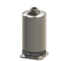
| Apogee-M is a highly accurate Motion Sensor or MRU (Motion Reference Unit) in a titanium subsea housing.The ITAR Free Apogee-M is the most accurate motion sensor based on the robust and cost-effective MEMS technology. |
 |
Allowing GNSS input, the Apogee provides a real-time heave accurate to 5 cm. For more simplicity, the user doesn’t have to enter the wave frequency; the Apogee automatically detects it and constantly adjusts to it.
Apogee comes also with a unique delayed heave feature with no additional software nor user action. This specific algorithm allows a more extensive calculation, resulting in a heave accurate to 2 cm displayed in real-time with a little delay.
Easy Configuration |
|
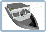
Web Interface with 3D ViewConfiguration is made easy throughout our intuitive embedded web interface where all parameters can be quickly displayed and adjusted. The new 3D View helps you to check your mechanical installation, especially your sensor position, your alignments, and lever arms. |
 |
Applications |
|
Marine |
|
|
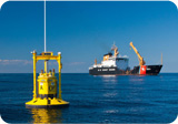
Apogee-M is an extremely accurate MRU which is operationnal on marine environment and up to 200 m underwater. It can be used for the motion monitoring of large vessel, barges, platform, cranes, and on-board equipment. It provides unmatched heave and motion data for Sonar stabilization, Helidek displays, Cranes Active Heave Compensation, etc.
|
 |
Complementary Equipment and Software |
|
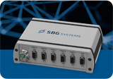
Connection, Synchronization, and PositioningThe SplitBox provides a simplified interface for easy connection and synchronization with external equipment, differential corrections, computers, or survey instruments. The SplitBox with integrated GNSS receiver additionally delivers navigation data with a large choice of positioning services (Marinestar, TerraStar, etc.). |
|